
Connecting neighborhoods on-the-ground with web-based crowd-mapping tools designed to explore, measure and act upon holistic urban health data from a citizen’s perspective
Urbinsight
A Global Data Initiative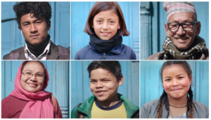
Urbinsight is designed for holistic, participatory planning processes. The goal is to provide engaged cities and citizens with the necessary tools and technologies to affect the resiliency and sustainability of their cities and settlements in a positive way.
Urbinsight capacity-building and planning projects achieve measurable outcomes — helping cities and states to more efficiently use and conserve natural resources, develop the ability to sustain key planning systems, and create mechanisms for community engagement. All these outcomes are the result of successful collaboration with local academic institutions and NGOs, and developing the capacity of these local organizations to engage and partner with the community and local/regional/national government bodies.
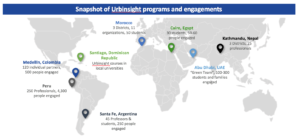
Some examples include:
- In Peru, we trained 75 professionals in collecting and using geospatial tools and community data for planning and green infrastructure proposals. We actively engaged over 800 citizens, politicians, academics, and students in PAR activities and passively engaged an additional 3,500 locals through public events, presentations and demonstration-workshops.
- In Morocco, we involved 50 students, 6 community organizations, 5 non governmental organizations, and citizens in testing a new method of crowdsourcing and crowd-mapping of environmental data, in Casablanca. Indicators were collected included Air Quality, Energy Food, Materials, Soil, Water, and Biodiversity.
- In Nepal, we are engaging Urbinsight materials and the Ecocity Framework with leadership from the Kathmandu Valley’s local governments, led by the Municipality of Lalitpur. Working with a Core Team that include the Muncipality, Tribhuvan University, UN Habitat and several key local NGOs, we are developing Ward (neighborhood) level plans in coordination with UN Environment’s Cities Unit. The efforts are deepening into the development of a national Ecocity Network that will seek to replicate the neighborhood approach throughout Nepal as a city-to-city network and learning exchange.
- In Medellin, Colombia since 2014, we have trained 120 individuals involved in municipal planning. These people and their agencies successfully completed local and regional assessments to inform ongoing planning and implementation strategies for waste, water, energy, food and materials in a participatory process that included community organizations and residents.
OUR APPROACH
The ecocity approach as expressed through the Urbinsight project can be characterized as precise and affordable local remedies based on thoughtful analysis of the symptoms and conditions, much like the prescriptions of eastern-style healers. The interventions are meant to be selective in order to protect, restore and improve traditional urban fabric and social networks.
Small, effective and cumulative interventions can occur through coordinated initiatives primarily managed at the household, community and neighborhood level, supported by policies and programs established at the city level.
ECOCITY ANALYTICS
Urbinsight utilizes an eco-smart analytic tool, a diagrammatic system visualization that can be redrawn and reframed to highlight existing circumstances and solutions for improving biological-geological conditions involving energy, water, materials and food.
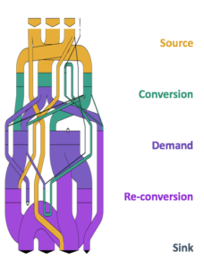 The calculation method for environmental accounting is referred to as Materials Flow Analysis (MFA). MFA tracks flows as a balanced set of input-output accounts. The inputs are either resources derived directly from nature (rainwater for example, or local sunshine and biomass) or resources imported from other regions. Inputs are then tracked as they flow through the city’s infrastructure and buildings.
Typically the input flows are first processed – for example rain might be filtered, sunshine converted to electricity, or biomass burned to create heat. After processing, the flows are used to satisfy demand for services – things like drinking, lighting, and cooking.
We visualize these flow diagrams using MetaFlow Software made by Graphical Memes. MetaFlow as a key tool in elucidating urban metabolism for the purposes of designing ecologically healthier cities and communities, as determined by the International Ecocity Framework and Standards.
Using the MetaFlow tool, Urbinsight participants generate interactive system-wide diagrams of energy, water, waste, transportation, mondy, carbon and other flows, using methods peioneered by Graphical Meme’s co-founder, Dr. Sebastian Moffatt. Unlike typical diagramming tools, MetaFlow does all its diagram layout and drawing automatically, with the help of sophisticated mathematical algorithms developed by Graphical Memes’ co-founder Dr. Philip Mansfield. This allows planners to quickly compare and assess various solutions rather than get bogged down with the details of manually routing and positioning diagram elements.
THE GUIDE TO MEASURE PROGRESS – THE ECOCITY FRAMEWORK AND STANDARDS
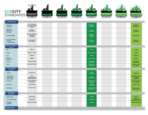
The Ecocity Framework and Standards comprises 18 standards in four categories – urban design, bio-geophysical conditions, socio-cultural features and ecological imperatives. It is a diagnostic tool for cities and citizens to measure progress towards ecocity conditions. Designed for a wide range of users, including both novices and experts, the Framework charts a city’s steps forward — from existing conditions to “threshold” ecocity standards and beyond.
Process & Methodology
An important consideration within the context of participatory planning is the means through which data is being aggregated and disseminated. In an effort to democratize access to planning and development data, the process and methodology of Urbinsight is fundamentally participatory and inclusive. This framework extends through the collection and synthesis of base layer data to the environmental assessments and use of the Urban Metaflow toolkit, facilitating partnerships and knowledge exchange between municipal governments, educational institutions, and community based organizations.

EcoCompass
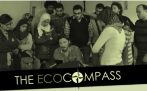 Urbinsight has an integrated library of versatile educational resources entitled the EcoCompass, which is a participatory research curriculum for urban resilience that was developed in partnership with multiple universities. The EcoCompass includes training-of-trainers (TOT) resources, interactive workshop activities, downloadable presentations, a database of best practice documents, video tutorials, and exchange forums where ideas and queries can be posted.
Learn more about the EcoCompass’ framework and scope of engagement.
Pilots & Partnerships
The Urbinsight project is defined by partnerships at multiple levels.
Community: Our primary focus is to identify a Community Based Organization who can lead and inform the community engagement process.
Institutional: We look towards working with education institutions and partners to implement curriculum related to participatory research and geographic information systems.
Municipal: City level partners are instrumental in providing us with data and information to help guide and frame the ground level analysis which the communities contribute to.
Global: Our goal is to create cross city analysis to identify best practices globally that can empower citizens worldwide to create sustainable changes in their or urban context.
